11er stats & stories
ranges 🏔
The list consists of every summit in Idaho over 11,000′ high with at least 300′ of prominence (vertical separation from taller neighbors). They’re located across several ranges:
- Lost River Range – 48 (42%)
- Pioneer Mountains – 31 (27%)
- Boulder Mountains – 17 (15%)
- Lemhi Range – 10 (9%)
- White Cloud Mountains – 8 (7%)
- White Knob Mountains – 5 (4%)
- Beaverhead Range – 4 (3.5%)
difficulty 🧗♂️
Climbing routes are rated using the Yosemite Decimal System. Here’s how the 11ers stack up:
- Class 1 (trail hiking) – 0
- Class 2 (off-trail hiking) – 41
- Class 3 (scrambling) – 76
- Class 4 (scrambling with exposure) – 5
- Class 5 (technical climbing) – 1
snowboarding 🏂
So far I’ve made snowboard descents on all 9 12ers and 55 of the 11ers. Some of those were on my first visit to the summit and some were a repeat ascent. I really look forward to late spring now because there’s nothing cooler than combining my two favorite hobbies!
SNOWBOARD SUMMIT PHOTOS GALLERY
human sightings 👀
Generally I wouldn’t see a soul all day during my outings in Idaho’s mountains—especially since I mainly hike on weekdays. I might see people on the trails that I use to start and end my journey, but once I leave the trail I’m in no-man’s-land. Here are the few exceptions:
- Borah Peak: Another party of 2 summited that day. On my way out I met two Michiganders who were doing a short warm-up hike to get acclimatized for the next day. I’m grateful that was my first experience there because it tends to get rather hectic these days.
Lost River Mountain: Another group of skiers started up at the same time as us then bailed halfway. On our descent we passed by 2 climbers on their way up the Super Gully.
Hyndman Peak: A Saturday during prime climbing season on the most popular peak around. We saw many other parties.
USGS Peak: Monday, July 5 was “Independence Day Observed” so I would have expected traffic on the more popular peaks, but this one is tough to access and doesn’t see many visitors. As Daniel and I were approaching the summit we saw someone standing on top. We got up there and chatted with Roberto for a bit before he descended. This was the only 11er summit I’ve ever shared (with someone not in my party).
Sacagawea Peak: So I didn’t actually see anybody on this mountain, but it does share 3/4 of its standard route with Borah. When I agreed to climb it on a Saturday in July it was sort of a joke to me to go experience a peak-season crowd on Idaho’s most popular peak. There were a few hundred hikers out there. Exactly like we had joked about, once we branched off from ‘Chicken Out Ridge’ we heard people shout, “You’re going the wrong way!!”
Goat Mountain: This one was an odd coincidence. We went for a mid-week backpacking trip up the trailless basin. Minutes after we dropped our packs another group walked up behind us and camped higher up the basin. We couldn’t believe it. Then the next morning as we headed out toward the peak we passed by their camp and they literally started hiking right next to us toward the same unpopular mountain. I was flabbergasted at that point.
They didn’t seem like avid peakbaggers since they didn’t know the peak’s nickname. Just some locals looking for a new adventure. My group veered off to go climb Florian’s Nudl first and we didn’t cross paths with them again.
Castle Peak: As I departed to descent the west face I noticed 2 climbers coming up the south face. That was on a Saturday.
Lonesome Peak: I was hanging out on the summit and could hear voices down at Lonesome Lake on the other side (the highest named lake in Idaho, I believe). I spotted a group of tween-age boys who must have been on a backpacking trip. We exchanged hellos and within a minute or two they decided they should also climb that mountain! The funny part to me was that they were going up an undocumented route up the east face. It’s an easy route—just not the way any climber would choose to access that peak since the lake is essentially a 2-day hike in from the nearest trailhead. I headed out to another peak but I did see that their mission was successful.
skye 🐶
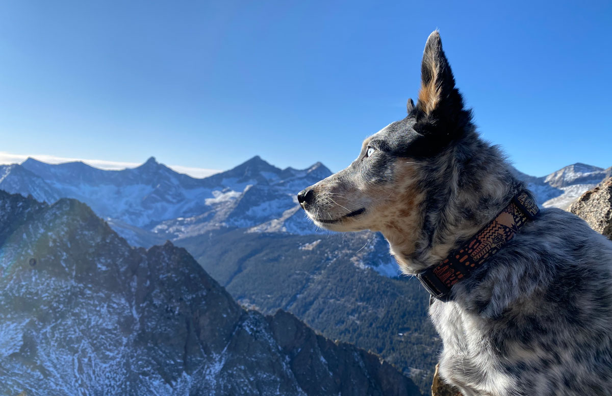
My dog, Skye, has summited 31 of the 123. I would leave her at home on trips where I thought the scrambling might get too serious (but she is an amazing scrambler). Also if I was going to be up on ridgelines connecting summits for hours I didn’t want to be carrying that much extra water. Skye unfortunately had a ligament injury summer 2020 and was out the rest of that season.
partners 👯♂️
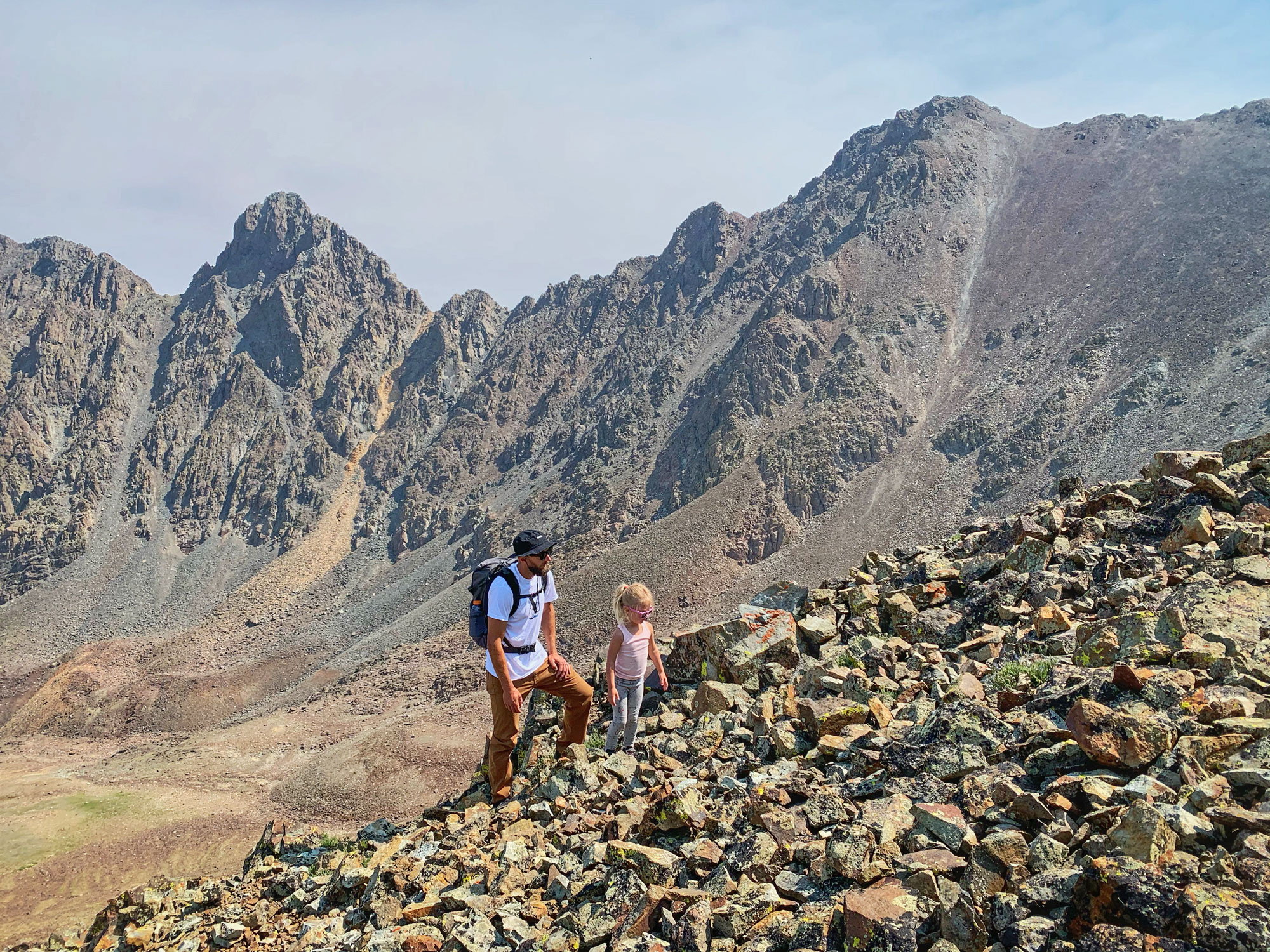
I did around half of these peaks solo. Other times I was joined by family or friends. During the latter half of my 11er quest I met some friends with the same ambitions and speed in the mountains. Daniel Todd and Haylee Stocking have joined me on many of these summits and our trips together are a blast. We’d team up more if we weren’t scheduling around parenting, jobs, school…
link-ups 🔗
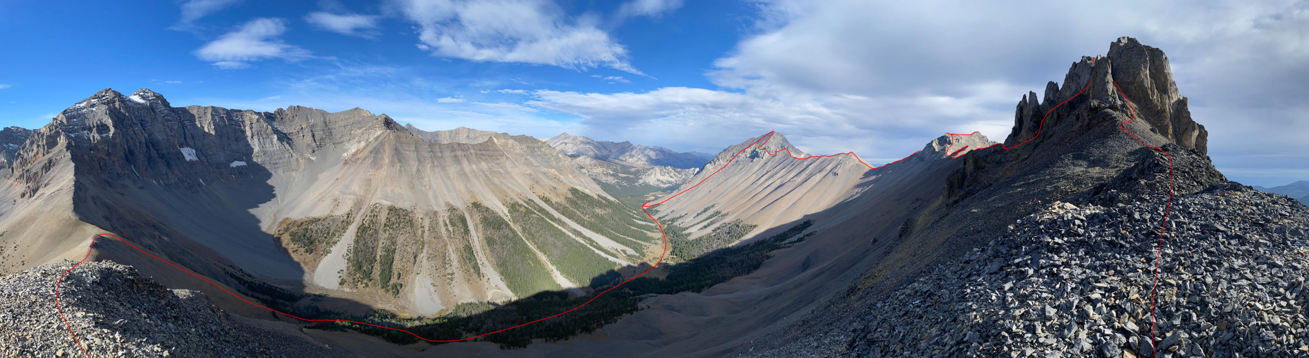
There’s a certain beauty to climbing mountains one at a time. You honor that peak with your full attention, and savor your single summit visit without being concerned about your next objective. But that’s not how I did this. Climbing multiple peaks in a day is obviously more efficient, but it also introduces new challenges—and those challenges are some of my favorite things about peakbagging. I’m not really into reading instructions on how to climb a particular mountain. I enjoy poring over digital maps and satellite imagery then coming up with my own approach. I’ll start with checking out all the driving possibilities to find the highest elevation I can 4×4 to. Then I’ll look around at all the neighboring peaks and brainstorm options for visiting more than one. I’ll roughly measure distance and elevation gain and try to figure out how much is possible in a day. I’ll often plan a route and wonder if it’s going to be too much, or if the connections will even be possible. Those uncertainties make it so much more exciting than just “going out for a long hike”. Then comes the challenge of execution. Problem-solving the terrain. Having the stamina and determination to keep moving. That’s what I’m out there for.
Here’s how many 11ers/12ers I did in each day of climbing. Some peaks were repeated so the total is more than 123 summits:
⛰ – 50 trips
⛰⛰ – 19 trips
⛰⛰⛰ – 7 trips
⛰⛰⛰⛰ – 3 trips
⛰⛰⛰⛰⛰ – 1 trip
routes 🔃
As mentioned above I like “reasoning from first principles”, or coming up with my own way of doing things. As a result I did end up climbing (or at least descending) countless undocumented routes. A few standouts:
- The Riddler, South Ridge: This is one of the most challenging peaks on the list. Aside from the daring connection from Diamond, the only known route on this peak was through the complex labyrinth of gullies on the southeast face. Daniel Todd and I came at this peak from a different direction, since we had climbed two other peaks first. We were poised to drop down a bit and ascend the standard ‘Baugher route’. As we got closer I was sizing up the south ridge. It looked like we had a pretty good chance of finding a way up it. Pros: we would be spared from having to drop down a few hundred vert on the way in and the way out. We would also get to pioneer a new route. Cons: If the route didn’t go, we probably wouldn’t have enough time to backtrack and climb the face—which means coming back for another day of climbing there. There was a possibility of doing half & half via a traverse to the face but that was another unknown. We decided to go for it. There were a couple tricky scrambling sections but nothing that felt ‘irresponsible’. I remember popping my head up from the last one and seeing the rest of the way was an easy walk to the summit. It was a very satisfying accomplishment.
Boulder Lake Peak, East Ridge: This peak had always been climbed from trail leading to the lake on the west side. During my many drives down the rugged Wildhorse Creek Road I would look up at BLP and think, “It’s just right there. It totally looks like you start from here and cruise to the top.” I finally went out there to try and it worked. It was also a really enjoyable route.
Mount Corruption, South Ridge: This is by far the most iconic peak on the Pahsimeroi side of the Lost River Range. I looked at the photo of Corruption I had taken of it from Little Regret Peak. The south ridge looked possibly doable if I could get past the ugly-looking towers at the base of it. This would allow me to connect it to one or two other peaks on the list. I got out there on a clear fall day and was getting blasted by wind as I picked my way through a few miles of ridgelines. I was starting to feel sluggish when I finally got to Corruption. The towers blocking the ridge were a nuisance as expected, but then the path up the shoulder was a breeze. When I topped out it was an amazing rush fueled by equal parts of achievement and relief.
USGS Peak, South Ridge via Mt. McCaleb: On my first visit to Mt. McCaleb I looked back at USGS Peak and was pretty sure I could shoot over there. I crunched some numbers and decided it was not in the cards as an impromptu add-on that late September day. 3 years later I finally got back there with Daniel Todd. We set out to complete “The McTriple”: Little Mac + Mt. McCaleb + McCaleb Benchmark (the official name for USGS Peak). I was expecting the only challenge to be the endurance test, but we actually encountered some knife-edge scrambling along the McTraverse. That added some excitement to an otherwise smooth and simple route. Endurance didn’t seem to be an issue because we knocked it out in just under 7 hours car-to-car*.
*starting from the fence at 7000′. no cheating via the closed road
Lorenzo Peak, Northeast Ridge: This was one of the first big link-up days I designed. The Boulder crest sees plenty of action and this route was almost certainly climbed—but it was undocumented in the peakbagging world so it was experimental to me.
I attempted to ride my dual sport motorcycle up to Boulder City. After enduring much of the brutal “road” paved with wet bowling balls, I couldn’t get past the steep crux. It was a struggle to turn the bike around I dropped it in the process. When I finally got the bike down to where it could be parked, I was drenched in sweat on a cool October morning and now had quite a bit of extra hiking to do. It wasn’t looking good to make it all the way back to my final objective. It all worked out, and the final scramble up to Lorenzo was exciting, enjoyable, and quite stable by Boulders standards.
The next fall I got my Jeep back there to access some other peaks. I made it, but I never need to do that again. That drive—which gets worse every year—is now best reserved for side-by-sides.