stats

history 📖
The history of the list is something that may not come to mind but should be considered. It was only a few decades ago that USGS completed its topographic map series for Idaho. From there, someone had to comb through each one and find all the points that count as peaks. In addition to the summit elevation, peakbaggers are interested in a summit’s prominence, or vertical separation from the surrounding terrain. In Idaho we use a 300’ cutoff—which was adopted from Colorado. That’s how we decide when a sub-peak or bump on a ridge counts as a separate summit.
I’m not sure how far back the Idaho 12ers list (9 highest peaks) goes, but the first reported completers were in the late 20th century. The next set to be compiled was the 11ers. In 2005 local map enthusiast Brandon Melander finished that task and found 114 11ers. About the same time, John Kirk had produced the 11ers list as he was building out his peak database, Lists of John, so the two were able to compare results. In 2012 George Reinier and John Roache became the first climbers to complete climbing the Idaho 11ers.
The work continued for John Kirk, because we was compiling a website that includes every peak of any elevation that has 300’ of prominence—for the entire country. That includes nearly 6000 summits in Idaho alone. By 2008 he had finished compiling the Idaho 10ers list. So interestingly enough, we haven’t had access to such a list for very long. I will note that most of these are included in the ‘Idaho Peaks 10,000 Feet or Higher’ list on page 373 of Tom Lopez’s Idaho: A Climbing Guide, published in 2000. While quite extensive, that list just didn’t have the level of topo-analyzing scrutiny that John Kirk was executing. No one had ever finished the list of 10ers, but Rick Baugher—Idaho’s most prolific peakbagger by a longshot—had come the closest with around 80% completion.
So there it is; the 10ers list is established in 2008 and set in stone, right?…
LiDAR 🧑💻
For the past 15 years or so, USGS has commissioned the collection of LiDAR elevation data for the entire country. This is essentially a 3D laser scan of the topography. It yields around one data point per square foot and is accurate to within a few inches. Traditionally, we’ve been getting our elevation information from hand-drawn maps created by surveyors out in the field. The challenges of creating these maps makes them prone to some level of inaccuracy. In addition, for most saddles and many summits the maps don’t feature an exact elevation—they only offer contour lines drawn every 40 feet. This means that the new LiDAR elevation data are giving us a far clearer picture than we’ve had before, and the lists of peaks that we’ve compiled will see some changes. In 2023, USGS started to release some batches of this new data for Idaho’s mountains and the list of peaks I was chasing saw some changes. Interestingly enough, I’ve also been the one to step up and dig into these data to recalculate the new measurements as a volunteer contributor for Lists of John. Currently the 10ers and Top 500 lists are around 70% LiDAR-verified—so we’ll almost certainly see a few more changes when the remaining data become available. I’ve tried to “cover my bases” as much as possible and climb all the peaks that have a chance of being added to the list. Here are the new peaks that have been added to the 10ers and Top 500 lists due to LiDAR updates:
11ers/Top 500
“No Regret Peak” 11,996’ (LiDAR rise 314’ vs. mapped at 272’)
“Ibex Creek Peak” 11,195’ (LiDAR rise 307’ vs. mapped at 275’)
10ers
“Gilmore East” 10,744’ (replaced Gilmore Peak on the list since it’s the higher of the two)
Peak 10734 (LiDAR rise 315’ vs. mapped at 298’)
Peak 10577 (LiDAR rise 302’ vs. mapped at 278’)
Peak 10548 (LiDAR rise 334’ vs. mapped at 281’)
“Little Inyo” 10,474’ (LiDAR rise 301’ vs. mapped at 299’)
Peak 10428 (LiDAR rise 304’ vs. mapped at 288’)
Peak 10203 (LiDAR rise 302’ vs. mapped at 280’)
Peak 10177 (LiDAR rise 321’ vs. mapped at 273’)
“Methodist Peak” 10,113’ (LiDAR rise 332’ vs. mapped at 280’)
Peak 10099 (LiDAR rise 308’ vs. mapped at 280’)
Peak 10047 (LiDAR rise 319’ vs. mapped at 299’)
Peak 10014 (LiDAR elevation 10,014’ vs. mapped at 9940’ / LiDAR rise 347’ vs. mapped at 280’)

legacy peaks ☠️
There were also casualties with these updates. Since no one had ever finished the original 10ers list, I wanted to make sure I got that too—“for old time’s sake” 😆. There were a few of these “legacy peaks” that I visited after I knew they weren’t ranked. Try to guess which ones!
11ers/Top 500
Lime Mountain 11,180’ (LiDAR rise 294’ vs. mapped at 319’)
“North Cabin Mountain” (LiDAR rise 293’ vs. mapped at 303’)
10ers
Italian Peak 11,003’ (replaced by “Italian East” which was shown to be the higher of the two summits. Also went from being the highest 10er to the lowest 11er. Still in the Top 500, but no longer in the 10ers)
Peak 10785 (while this mountain is located on the Continental Divide, the highpoint is clear within Montana)
Gilmore Peak 10,735’ (replaced by “Gilmore East” which was shown to be the higher of the two)
Senate Peak 10,516’ (LiDAR rise 293’ vs. mapped at 320’)
Peak 10333 (LiDAR rise 296’ vs. mapped at 320’)
“Judas Peak” (LiDAR rise 219’ vs. mapped at 320’)
Targhee Peak 10,279’ (LiDAR rise 286’ vs. mapped at 320’)
“Liberty Mountain” (LiDAR rise 295’ vs. mapped at 320’)
Peak 9998 (LiDAR elevation 9998’ vs. mapped at 10,001’ Still in the Top 500, but no longer in the 10ers)

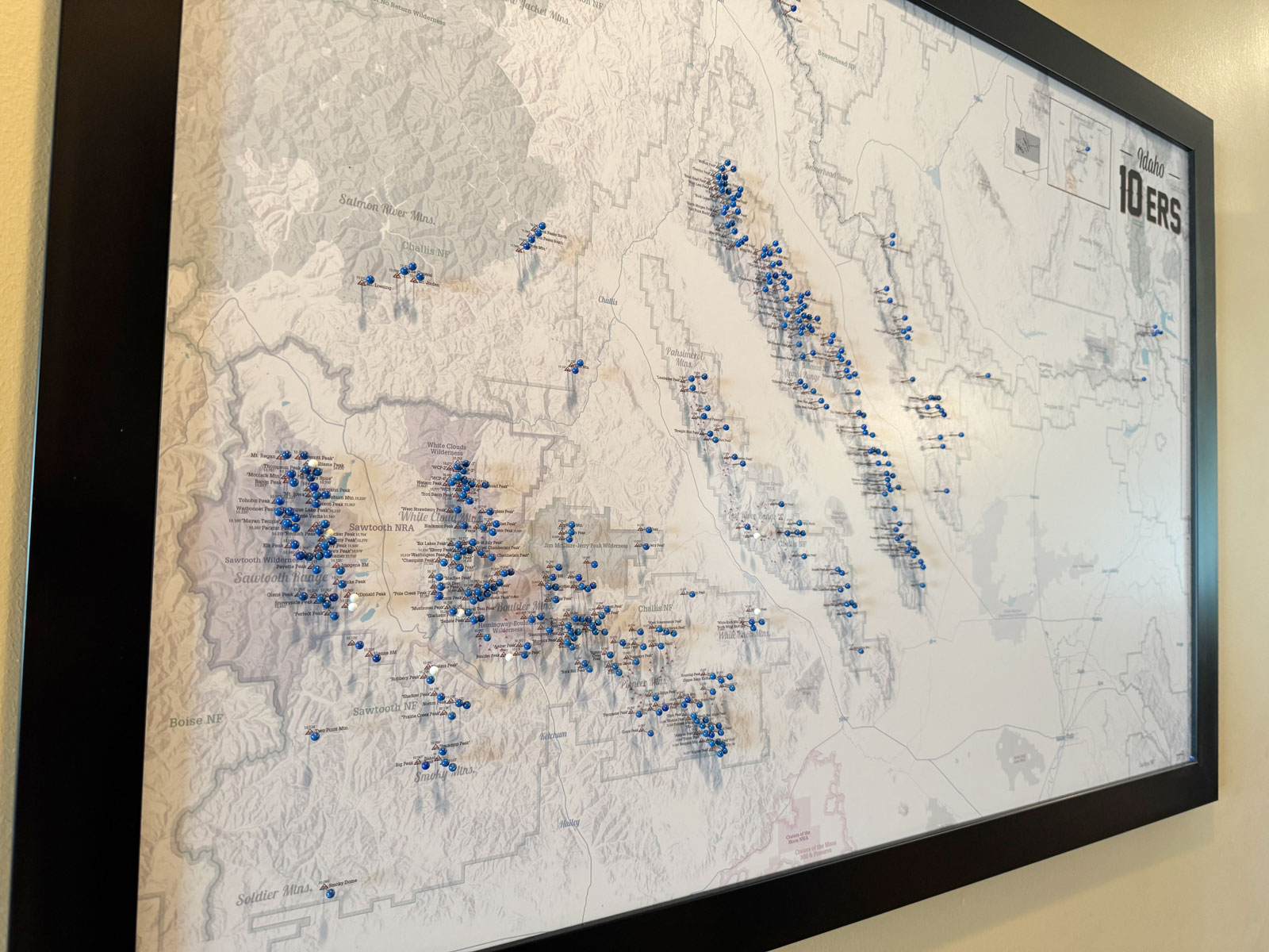
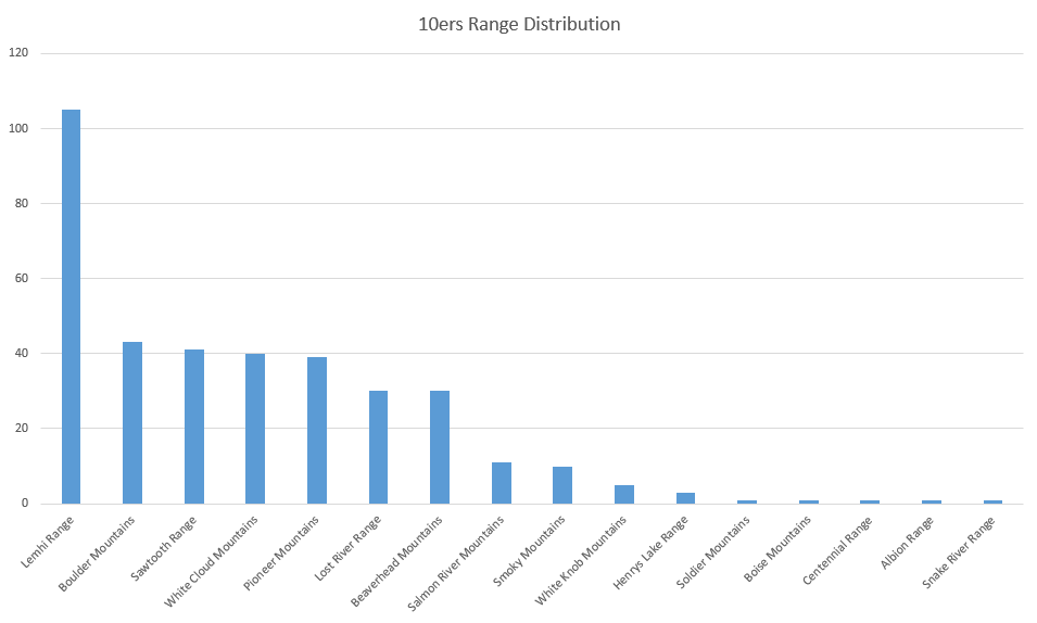
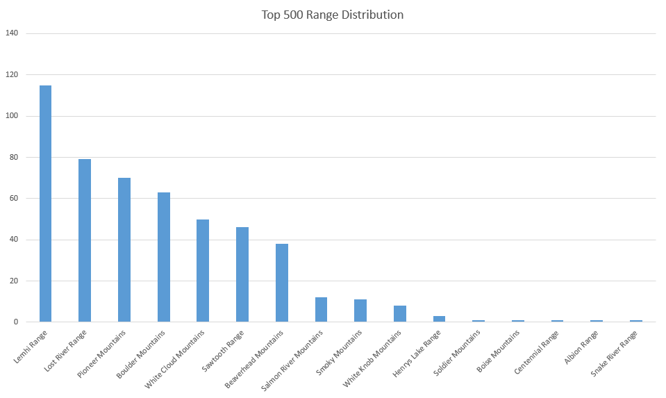
ranges ⛰️
The short list of Idaho 12ers is almost all within the Lost River Range. The 11ers list branches out into several ranges, and naturally the 10ers list—which currently includes 362 peaks—features even more variety. They are still generally confined to central Idaho, with a few stragglers in the southeast corner of the state [MAP]. It works well for me that there are none in the panhandle, as that is a very long drive from where I live.

access🚦
498 of Idaho’s 500 highest peaks are located within a National Forest (Thanks, Teddy!), and the other 2 are on BLM land just outside of a National Forest. While there were a few occasions where the most convenient access to a drainage was blocked by a private ranch, no special permission is needed to climb any of these peaks.